


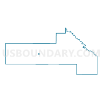
St. Leo Voting District, Yellow Medicine County, Minnesota
About
Outline

Summary
| Unique Area Identifier | 605001 |
| Name | St. Leo Voting District |
| County | Yellow Medicine County |
| State | Minnesota |
| Area (square miles) | 0.26 |
| Land Area (square miles) | 0.26 |
| Water Area (square miles) | 0.00 |
| % of Land Area | 100.00 |
| % of Water Area | 0.00 |
| Latitude of the Internal Point | 44.71734610 |
| Longtitude of the Internal Point | -96.05253850 |
Maps

Graphs
Select a template below for downloading or customizing gragh for St. Leo Voting District, Yellow Medicine County, Minnesota


Neighbors
Neighoring Voting District (by Name) Neighboring Voting District on the Map
- Burton Twp. Voting District, Yellow Medicine County, MN
- Omro Twp. Voting District, Yellow Medicine County, MN
Top 10 Neighboring County Subdivision (by Population) Neighboring County Subdivision on the Map
- Omro township, Yellow Medicine County, MN (161)
- Burton township, Yellow Medicine County, MN (148)
- St. Leo city, Yellow Medicine County, MN (100)